Sydney
Now: 19.9 °C
Today:  Mostly clear.
Tonight: 15 °C
Tomorrow: 24 °C
Mostly clear.
Tonight: 15 °C
Tomorrow: 24 °C  Shower or two.
Today, Tuesday: Mostly clear. Light winds.
Tomorrow, Wednesday: Partly cloudy. Patchy fog in the early morning. Medium chance of showers. Light winds becoming easterly 15 to 25 km/h in the middle of the day.
| Temperature | 19.9 °C | |
| Feels like | 19.2 °C | |
| Wet bulb temp. | 17.3 °C | |
| Minimum temp. | 19.8 °C | 11:39pm |
| Maximum temp. | 24.4 °C | 1:28pm |
| Dew point | 15.5 °C | |
| Humidity | 76% | |
| Wind |  13 km/h 13 km/h | |
| Strongest gust | 50 km/h | 5:56pm |
| UV index | 0.0 | Low |
| Pressure | 1025.0 hPa | |
| Rain since 9am | 0.0 mm |
Sydney Airport at 11:40pm.
Radar


UV index
| Now measured | Now forecast | Maximum measured | Maximum forecast |
| 0.0 | 0.0 | 8.7 | 8.2 |
| Low | Low | Very high | Very high |
| 12:40pm | 12:40pm |
| Moderate or above | Forecast | 9:02am–4:19pm |
| Measured | 9:01am–4:24pm |
Last 72 hours
Today
| Dawn | Sunrise | Sunset | Dusk |
| 5:42am | 6:06am | 7:14pm | 7:38pm |
Tomorrow
| Dawn | Sunrise | Sunset | Dusk |
| 5:41am | 6:05am | 7:14pm | 7:39pm |
Recent days
| Date | Min. | Max. | Rain |
| Tue 20 Oct | 14.8 °C | 0 mm | |
| Mon 19 Oct | 13.9 °C | 23.0 °C | 0 mm |
| Sun 18 Oct | 13.3 °C | 22.5 °C | 0 mm |
| Sat 17 Oct | 15.1 °C | 22.2 °C | 0 mm |
| Fri 16 Oct | 13.0 °C | 21.4 °C | 13.8 mm |
| Thu 15 Oct | 10.6 °C | 17.6 °C | 1.6 mm |
| Wed 14 Oct | 13.2 °C | 18.5 °C | 83.4 mm |
| Tue 13 Oct | 18.6 °C | 19.9 °C | 5.4 mm |
Space weather
Kaus seven day history
Next 36 hours
| Time | 11pm | Wed 2am |
5am | 8am | 11am | 2pm | 5pm | 8pm | 11pm | Thu 2am |
5am | 8am |
| Temperature (°C) | 19 | 17 | 15 | 19 | 22 | 24 | 23 | 21 | 19 | 18 | 18 | 19 |
| Chance of rain | 5% | 5% | 10% | 20% | 20% | 10% | 20% | 30% | 50% | 60% | 60% | 60% |
| Median rain (mm) | 0 | 0 | 0 | 0 | 0 | 0 | 0 | 0 | 0 | 0 | - | - |
| Wind speed (km/h) | 17 | 13 | 9 | 13 | 17 | 19 | 24 | 24 | 24 | 24 | 24 | 26 |
| Wind direction | |
|
|
|
|
|
|
|
|
|
|
|
| Dew point (°C) | 14 | 15 | 15 | 15 | 15 | 15 | 15 | 15 | 15 | 16 | 16 | 16 |
Next week summary
| Tomorrow Wed 21 Oct |
Thu 22 Oct |
Fri 23 Oct |
Sat 24 Oct |
Sun 25 Oct |
Mon 26 Oct |
Tue 27 Oct |
|||||||||
|
|
|
|
|
|
 |
|||||||||
| Shower or two. | Showers. | Shower or two clearing. | Partly cloudy. | Showers increasing. | Shower or two. | Possible shower. | |||||||||
| Max. (°C) | 24 | 23 | 24 | 27 | 29 | 26 | 22 | ||||||||
| Min. (°C) | 15 | 17 | 17 | 17 | 19 | 18 | 14 | ||||||||
| Any rain | 60% | 90% | 60% | 30% | 80% | 50% | 40% | ||||||||
| Rain (mm) | 0–5 | 3–15 | 0–3 | 0–1 | 1–10 | 0–3 | 0–2 | ||||||||
| 8am | 2pm | 8am | 2pm | 8am | 2pm | 8am | 2pm | 8am | 2pm | 8am | 2pm | ||||
| Wind (km/h) | 13 | 19 | 26 | 35 | 26 | 31 | 9 | 30 | 17 | 22 | 17 | 20 | |||
| Wind dir. | |
|
|
|
|
|
|
|
|
|
|
|
|||
| Dew pt. (°C) | 15 | 15 | 16 | 16 | 16 | 16 | 16 | 17 | 17 | 18 | 13 | 10 | |||
Complete forecast
Today, Tuesday 20 October
Mostly clear.
5% chance of rain
Mostly clear. Light winds.
Tomorrow, Wednesday 21 October
Shower or two.
Minimum: 15 °C Maximum: 24 °C
60% chance of rain 0 to 5 mm
Partly cloudy. Patchy fog in the early morning. Medium chance of showers. Light winds becoming easterly 15 to 25 km/h in the middle of the day.
Sun protection 9:10am to 4:10pm, UV Index predicted to reach 8 [Very High]
Thursday 22 October
Showers.
Minimum: 17 °C Maximum: 23 °C
90% chance of rain 3 to 15 mm
Cloudy. Very high chance of showers, most likely in the morning and afternoon. The chance of a thunderstorm in the afternoon. Winds northeast to southeasterly 15 to 25 km/h tending easterly 20 to 30 km/h in the middle of the day then tending northeasterly in the early afternoon.
Friday 23 October
Shower or two clearing.
Minimum: 17 °C Maximum: 24 °C
60% chance of rain 0 to 3 mm
Partly cloudy. Medium chance of showers, most likely in the morning and afternoon. Winds northeasterly 20 to 30 km/h becoming light during the evening.
Saturday 24 October
Partly cloudy.
Minimum: 17 °C Maximum: 27 °C
30% chance of rain 0 to 1 mm
Partly cloudy. Medium chance of showers in the morning and afternoon. The chance of a thunderstorm in the afternoon. Light winds becoming north to northeasterly 20 to 30 km/h during the day then becoming light during the evening.
Sunday 25 October
Showers increasing.
Minimum: 19 °C Maximum: 29 °C
80% chance of rain 1 to 10 mm
Partly cloudy. Very high chance of showers. The chance of a thunderstorm. Winds northerly 15 to 25 km/h turning northwesterly 15 to 20 km/h later.
Monday 26 October
Shower or two.
Minimum: 18 °C Maximum: 26 °C
50% chance of rain 0 to 3 mm
Partly cloudy. Medium chance of showers. The chance of a thunderstorm. Winds west to northwesterly 15 to 20 km/h turning south to southwesterly 15 to 25 km/h during the morning.
Tuesday 27 October
Possible shower.
Minimum: 14 °C Maximum: 22 °C
40% chance of rain 0 to 2 mm
Partly cloudy. Medium chance of showers. Winds southwesterly 15 to 20 km/h turning south to southeasterly 15 to 25 km/h during the day.
Issued as 9:53pm. Next forecast at 4:35am.
Weather situation
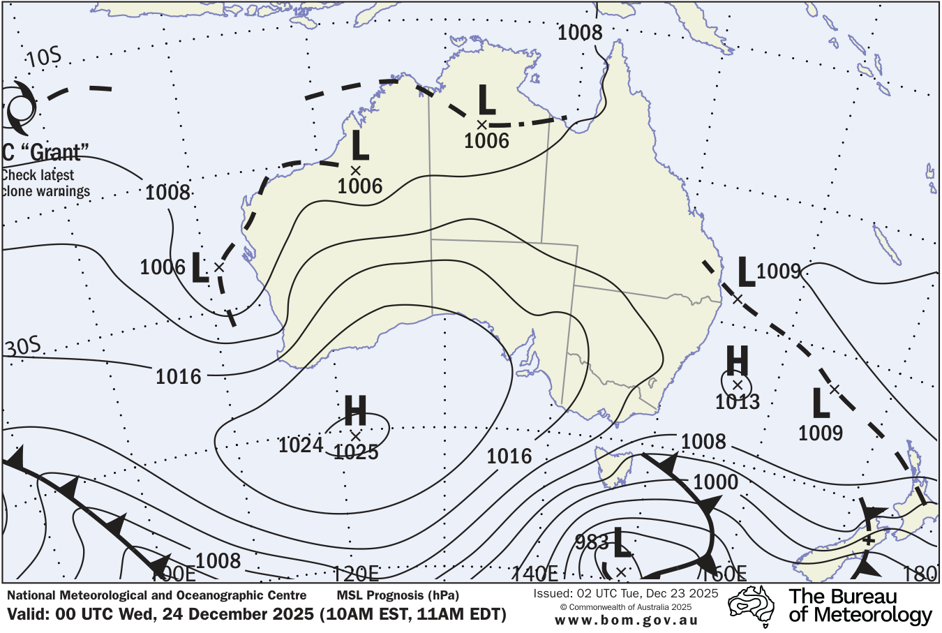
A high pressure system in the Tasman Sea extends a ridge across eastern New South Wales, maintaining an onshore east to northeasterly airstream, while an inland trough extends into the far northwest. This pattern will maintain showery conditions in many areas through the week. Then, a cold front looks set to cross the state during the weekend into early next week, bringing increasing showers and thunderstorms across the state, as the system combines with moisture drawn from the north.
Climate statistics
More details and data sources: